

Key take away from this report
June brought unsettled westerly flows for the beginning of the winter season. The month has been slightly drier than average especially in the Southeast of the region. South of Whangārei and across to Pōuto Point had well below average rainfall. Most above normal rainfall fell in the Far North and Hokianga via messy infrequent low weather systems. River flows are generally below normal for June due to below average rainfall, with the exception of the Far North and Hokianga. Even with drier conditions, groundwater is still recharging due to saturated soils.
Summary
- Northland’s average rainfall was 148mm which was 92% of expected rainfall for June.
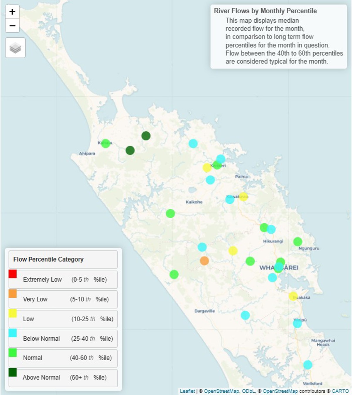
- River flows range from “above normal” to “low” across the region for this time of year and are generally higher in the north and west and lower in the south and east, reflecting June’s rainfall distribution.
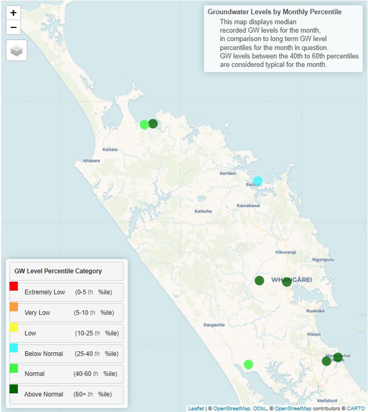
- Groundwater levels are “above normal” or “normal” for most of the region except for Bay of Islands where levels are “below normal”.
- The region’s soils are at or just below field capacity.
- El Niño conditions have now been reached; the event remains in its early stages; impacts on Northland’s weather patterns are yet to be fully felt but are anticipated later in the year.
- El Niño typically brings drier weather to Northland.
Rainfall
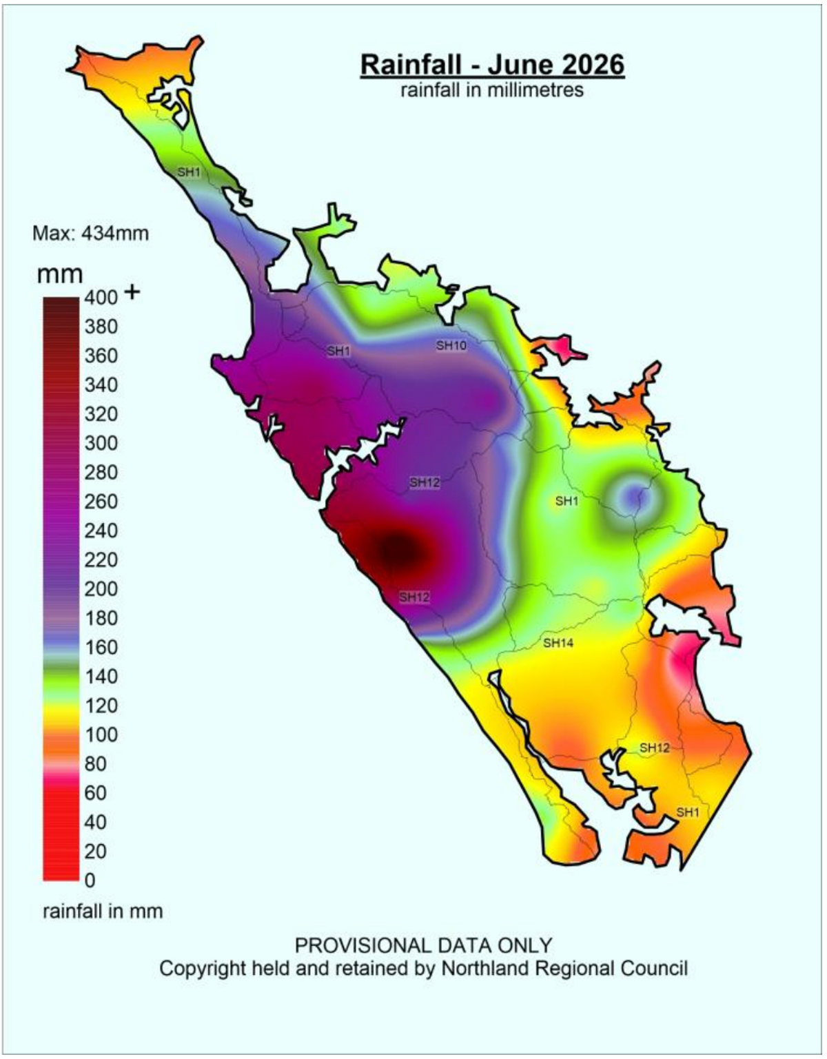
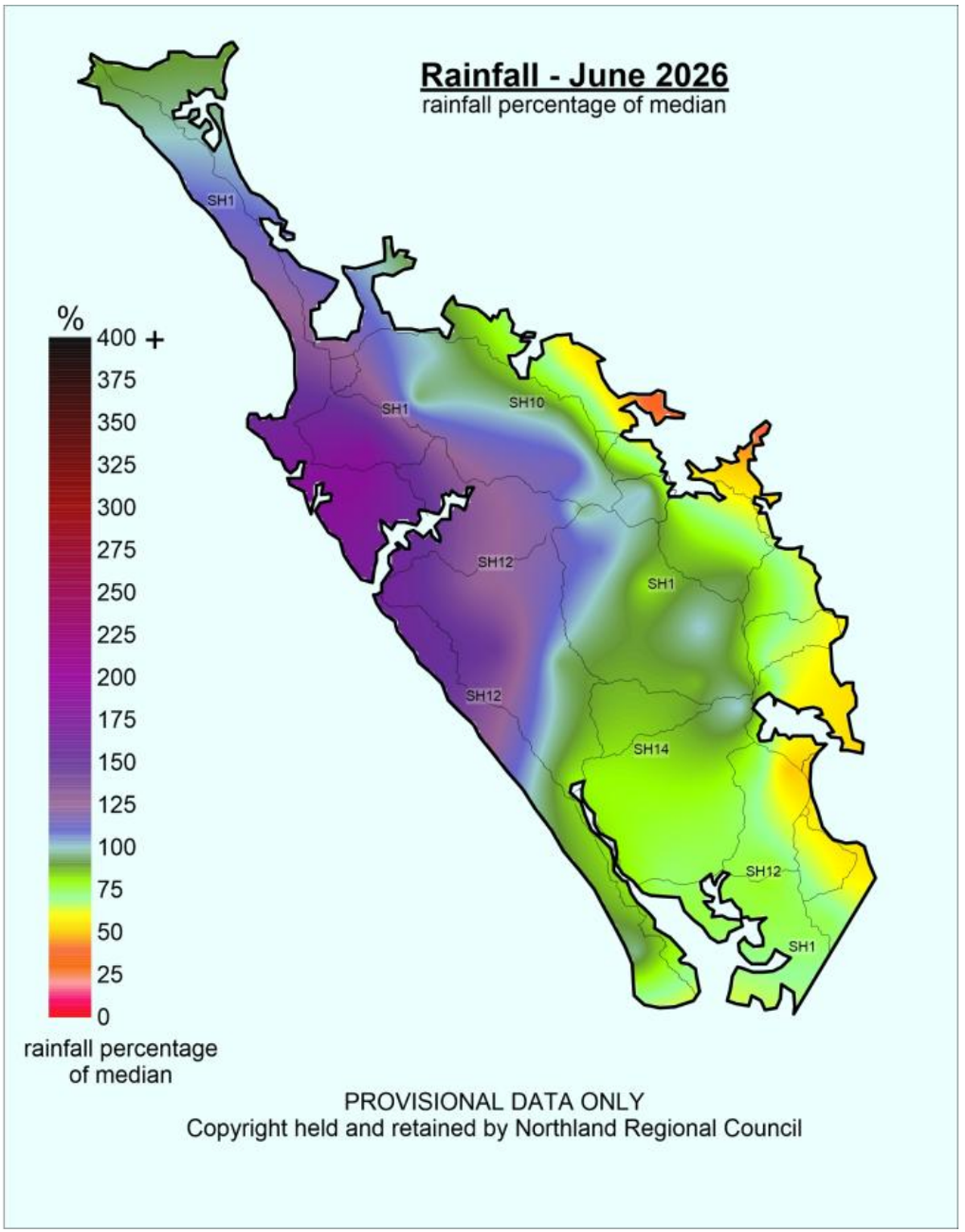
- Northland’s average rainfall was 148 mm across the region for June (Figure 1), which is 92% of the long-term median, or normal expected rainfall (Figure 2) for the month. Most of this rain was focused around the Far North, Hokianga and Tūtāmoe areas.
- The highest rainfall total for the month was recorded at Waimamaku at Weka Weka Road with 434 mm, 149% of normal expected.
- Other high recording rainfall stations include: Waimā at Tūtāmoe with 372.2mm, 147%; Takahue at Saddle Road 298.5 mm, 181%; Rotokakahi at Kohe Road with 290mm, 184%; Tarawhataroa at Larmer Road with 238.5 mm, 152%; Waitangi at Wiroa Road with 238mm, 116%; Whawharu at Topu B Tāheke with 207.5mm, 126% of normal expected rainfall for the month.
- The lowest rainfall for June was recorded at Whangārei Harbour at Marsden Point with 73 mm, which is 58% of normal expected rainfall
Figures 1 and 2: June 2026 rainfall distribution for Northland in mm, and in percentage of median. Showing an average of 148mm (92% of expected) rainfall for the region.
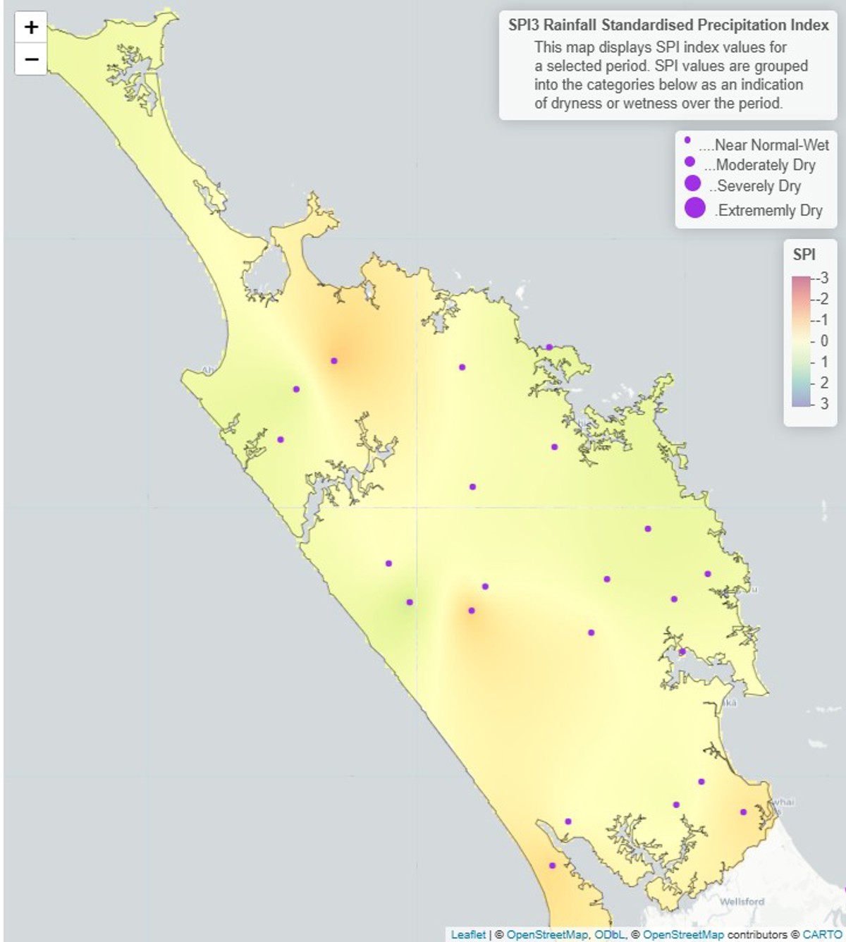
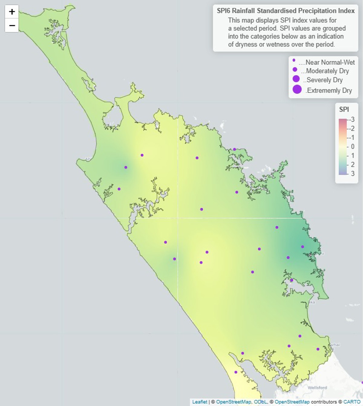
- Both the three-month and six-month Standardised Precipitation Index (SPI) (Figure 3 and 4) show that the region is “Near Normal – Wet”.
Figures 3 and 4: Standardised rainfall for Northland on a 3-month scale (April to June 2026) and a 6-month scale (January to June 2026).
River Flows
- June river flows for Northland range from “above normal” to “low” across the region, primarily “normal” to “below normal”. River flows are generally higher in the north and west and lower in the south and east, reflecting June’s rainfall distribution.
Figure 5: River flows in Northland for June 2026.
Groundwater
- Groundwater levels are “above normal” or “normal” for most of the region for this time of year. The exception is the Bay of Islands where levels are “below normal”.
Figure 6: Groundwater levels in Northland’s primary monitored aquifers for June 2026
Soil moisture
Summary of modelled soil moisture data from Earth Sciences New Zealand
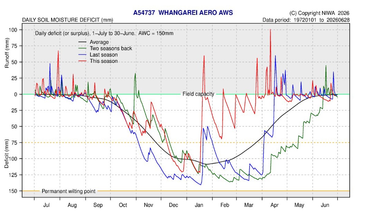
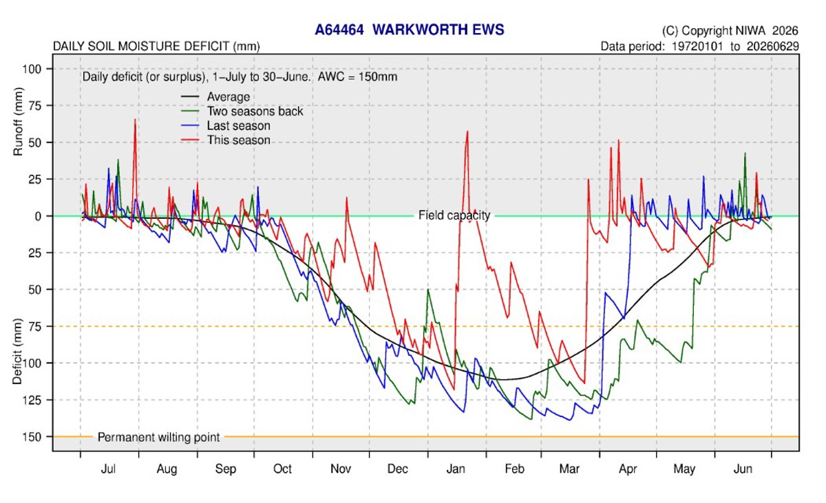
- The soil moisture deficit is calculated based on incoming daily rainfall (mm), outgoing daily potential evapotranspiration (mm), and a fixed available water capacity (the amount of water in the soil 'reservoir' that plants can use.
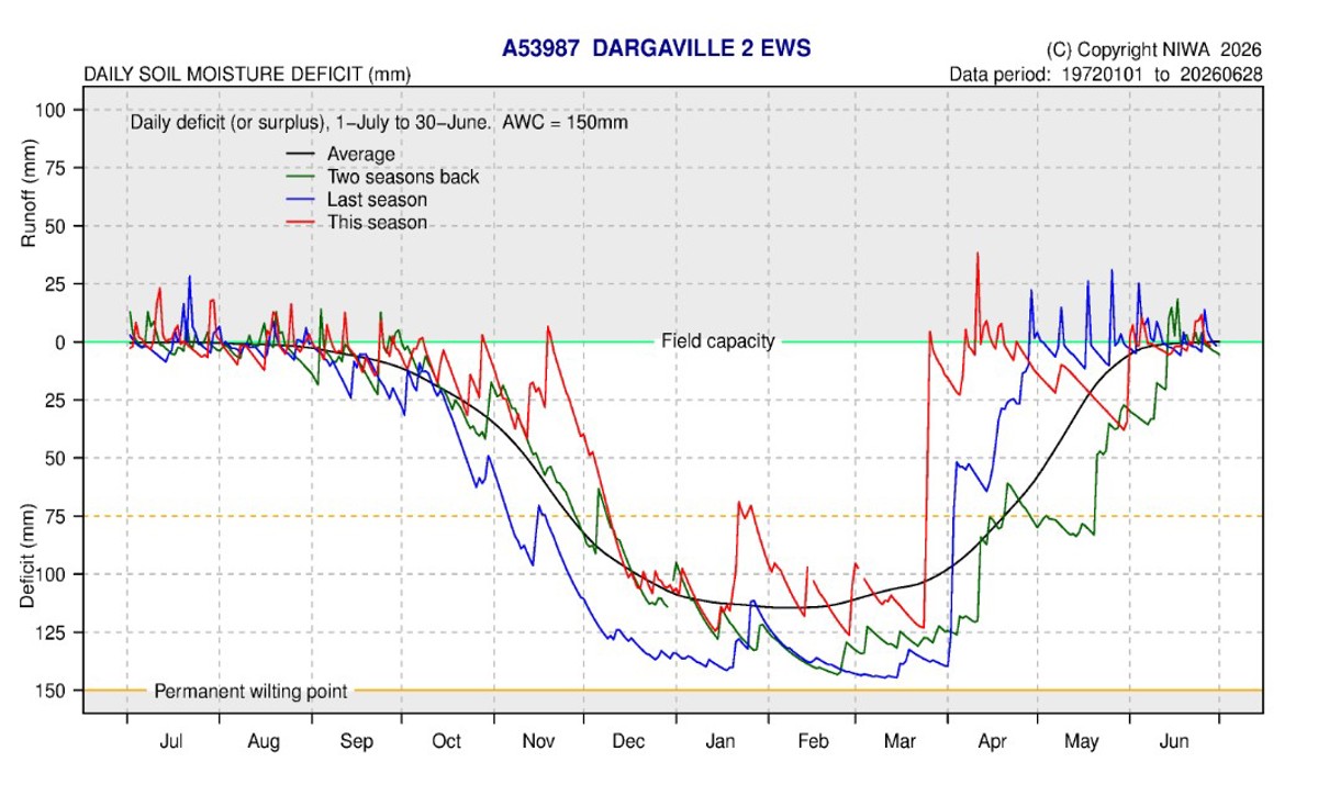
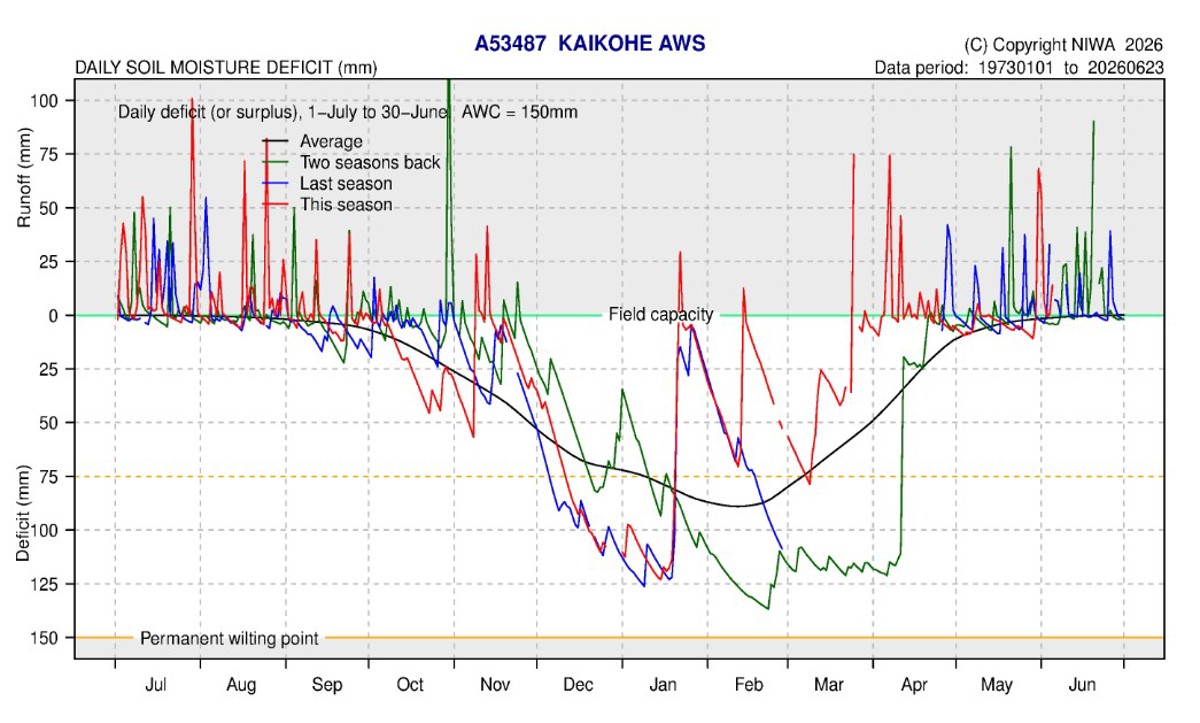
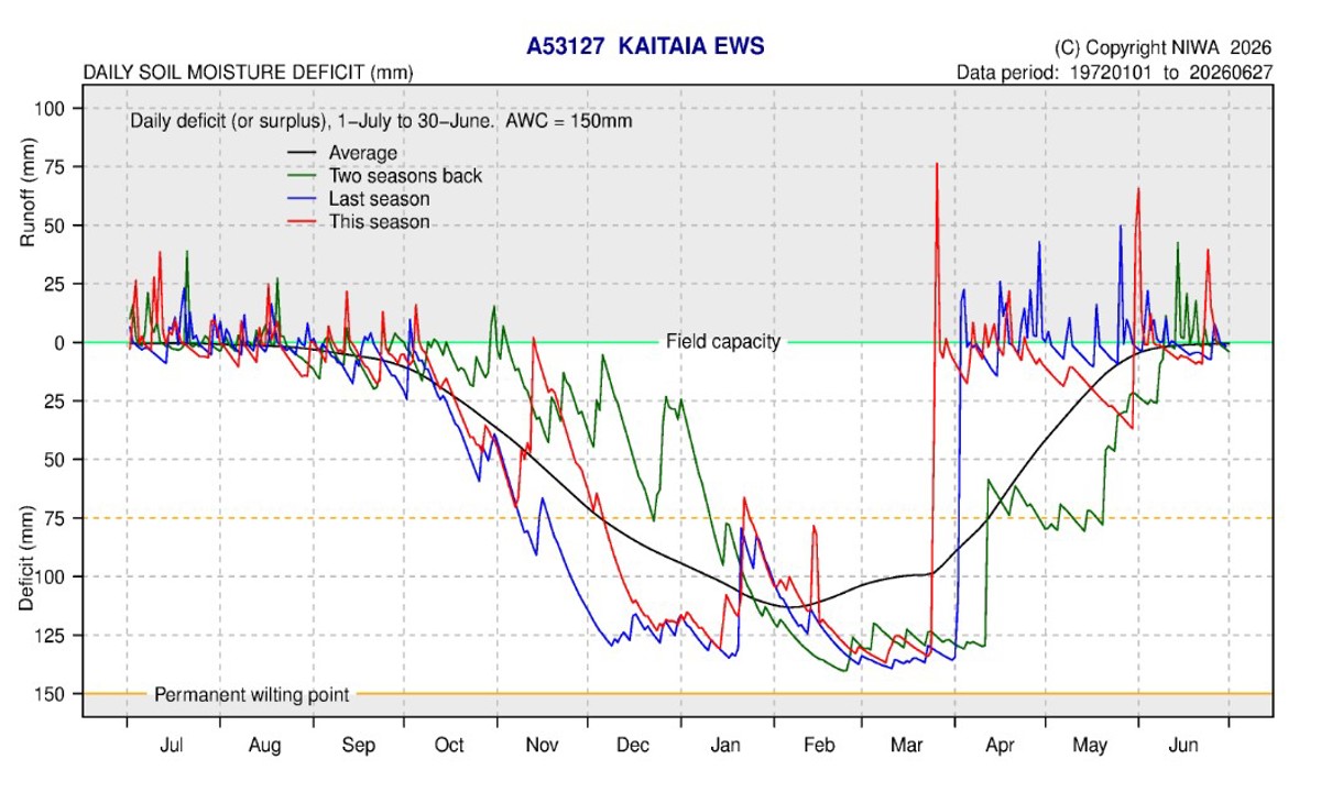
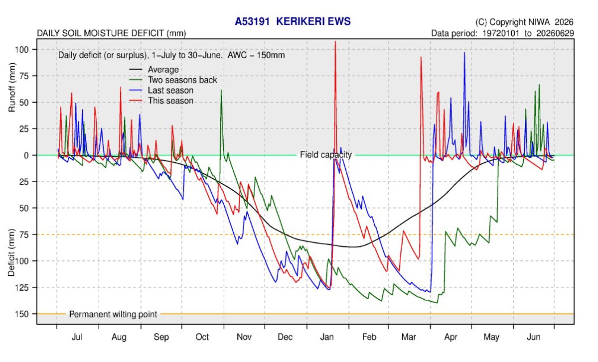
- Soil moisture is very close to average and is at, or just below, field capacity throughout Northland
Figure 7: Calculated daily soil moisture values at key areas around Northland, courtesy of ESNZ, data ending 29 June 2026.
Climate outlook for July to September 2026
Summary of climate forecasts from Earth Sciences New Zealand
Earth Science New Zealand’s full outlook for July to September 2026 can be found at: Seasonal Climate Outlook July - September 2026 (ESNZ | NIWA)
- El Niño conditions have now been reached in the tropical Pacific atmosphere and ocean, according to criteria assessed by Earth Sciences New Zealand. The event remains in its early stages; impacts on New Zealand’s weather patterns are yet to be fully felt but are anticipated later in the year.
- With Winter beginning, air flow patterns are expected to tend west or south-westerly. The prospect of below normal rainfall in Northland is likely to translate to below normal groundwater recharge creating challenges for water reliant sectors. There will be periods of active weather including, unusually windy conditions
along with notable temperature variability. - Temperatures are about equally likely to be near average (40% chance) or above average (35% chance).
- Rainfall totals are most likely to be below normal (50% chance).
- Soil moisture levels and river flows are about equally likely to be near normal (40 - 45% chance) or below normal (40% chance).
Table 1: Forecasted likelihood of above, near or below average climate conditions for Northland from July 2026 to September 2026, courtesy of ESNZ
(Expressed as % likelihood).
| Temperature | Rainfall | Soil moisture | River flows | |
| Above average | 35 | 20 | 15 | 20 |
| Near average | 40 | 30 | 45 | 40 |
| Below average | 25 | 50 | 40 | 40 |